Alfrick and Suckley walk
22 May 2013
The walk was organised and led by Jim Handley. The circular walk of about 5 miles was designed to view the sedimentary rocks of the Silurian and Triassic period and their effects on the local landscape around Alfrick and Suckley Hills. It also offered another opportunity to consider the history of the Mathon River in this area. The walk was written up by Roger Hunt.
The walk was based on the Geopark Way circular trail leaflet called “Alfrick and the Suckley Hills” (click here to download) The points referred to below are those shown in the leaflet and shown on the map below. We started at point 14.

Apart from the leaflet, the walk used a 2 part map giving separate Ordnance Survey (Explorer 204) and Geological Survey views of the area on an enlarged scale. This technique developed by the mapping sub-group is a perfect way to align the geology to the ground.
Knapp & Papermill Reserve to Alfrick (Points 14 to 1)
We began the walk at the Knapp & Papermill Reserve (point 14) where Jim reminded us of the overall geology of the area. The East Malvern fault which runs almost north-south through the Knapp reserve provides a very clear divide between the Silurian rocks to the west and the Triassic rocks to the east. The Silurian rocks being laid down over 400 Ma (million years ago) in warm seas whilst the Triassic were laid down over 200 Ma in semi arid conditions via rivers and streams. Subsequent folding of the land resulted in the formation of an anticline in the Silurian, whose subsequent weathering and overlying of other rocks has greatly influences the landscape of the area.
From the Reserve, the route partly follows a sunken lane cutting through the Triassic Bromsgrove Sandstone formation where the rocks were clearly red and of varying hardness with much evidence of badger setts in the softer materials. We also noted bands of conglomerate in the banks. These rocks were probably laid down under braided river conditions and hence the variety of textures.

Badger setts within the Triassic Bromsgrove Sandstone.
Arriving at St Mary Magdalene Church in Alfrick (point 1) we spent a little time looking at the building stone used which are described in the leaflet as being mainly of rubble stone. There is a large variety of local stone but also some which do not seem to fit the location, including one mystery variety which one might describe as a crystalline breccia/comglomerate. It showed obvious crystals of quartz.

The rich variety of building stone, St Mary Magdalene Church in Alfrick.
Alfrick to Crews Hill (Points 1 to 8)
From Alfrick, heading roughly west, the route crossed the East Malvern fault and the boundary between the Triassic Bromsgrove Sandstone and the Silurian Coalbrookdale formation (point 2). Of this almost 200 million years boundary there is no noticeable sign on the landscape! The route continued to head towards Crews Hill effectively following an imaginary section through the anticline and crossing bands of Woolhope limestone, Wyche formation and down in to Coalbrookdale formation in the valley. From the valley (point 4) and looking SSE towards Old Storridge Common the hard, narrow, steep sided limestone ridges show how the landscape has been created by the weathering of the anticline exposing its constituent layers.
Continuing up to the top of Crews Hill the double map indicated very clearly that we walked through a area of glacial head although there was nothing to show of it on the ground! At the top of the hill (point 6) we had magnificent and possibly unique views over 5 geological periods. Towards the north east are the Permian Clent Hills and the Ordovician Lickey Hills, to the east lies the relatively flat Worcester basin underlain by Triassic rocks and to the south east is Bredon Hill and the Cotswold escarpment of Jurassic rock. Finally further to the south are the Precambrian Malvern Hills – a total age span from 200 to 670 Ma.
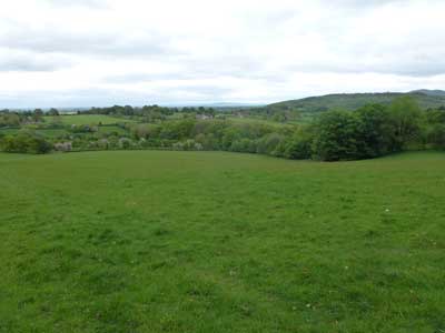
The commanding views at point 6.
On the top of Crews Hill, back in the Woolhope limestone, we discovered small quarries reputed to have been worked from the 18th century up to the early 20th century (between points 7 & 8). These were very small almost ‘one man band’ quarries! We hunted here, mainly unsuccessfully, for signs of fossils – a few bits of brachiopods and crinoids the best we could do!
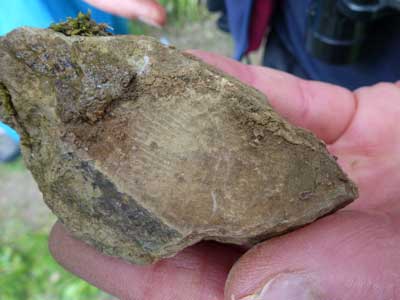
A brachiopod fossil found in the Crews Hill reserve.
A picnic lunch on the upper slopes of Crews Hill allowed us to savour the views across the hills of Storridge and Cradley, to the Malvern Hills in the distance and across the valley in front to Old Storridge Common and the hidden valley of Leigh Brook.
Crews Hill to the Reserve (Points 8 to 14)
From lunch our route took us down the valley to Leigh Brook near Mousehole Bridge (point 10). Following the brook we entered the Reserve and walked through to the area near the mill cottage (point 11). Here Jim pointed out the slope variations which marked the boundary between the Wyche Formation rocks to the north and the Cowleigh Park formation. The latter are the oldest Silurian rocks in the area (443 Ma). At this point Jim gave us a lesson on the history of the Leigh Brook and its association with the Mathon River which is believed to have flown from north to south along the western edge of the Malvern Hills before the Anglian ice age. At that time it was thought that a river flowed from the Stour catchment/Worcester basin along the course of Leigh Brook through the Reserve and into the Mathon River. Following the move of the Anglian ice sheet southwards around the Malvern Hills the Mathon River was blocked forming a huge lake which eventually overflowed north eastwards along the course of Leigh Brook, reversing its direction and scouring the gorge we see today (click here for diagrams from our walk in Sep 2010).

The Knapp and Papermill cottage.
Following the brook through the reserve, evidence of past floods was clear by the continuing scouring of the stream bed. A recent rock fall in the steeply banked edge of the stream (about point 12) appeared to show virtually horizontal bedding planes in the limestone. Might this indicate the middle of the anticline?
Near the end of the walk we crossed the East Malvern fault line again and looked at a small area of Permian Haffield Breccia, composed of various sized fragments of rocks from an earlier mountain range lying somewhere to the west.

Permian Haffield Breccia.